 On U.S. 163 headed to Monument Valley in Utah |
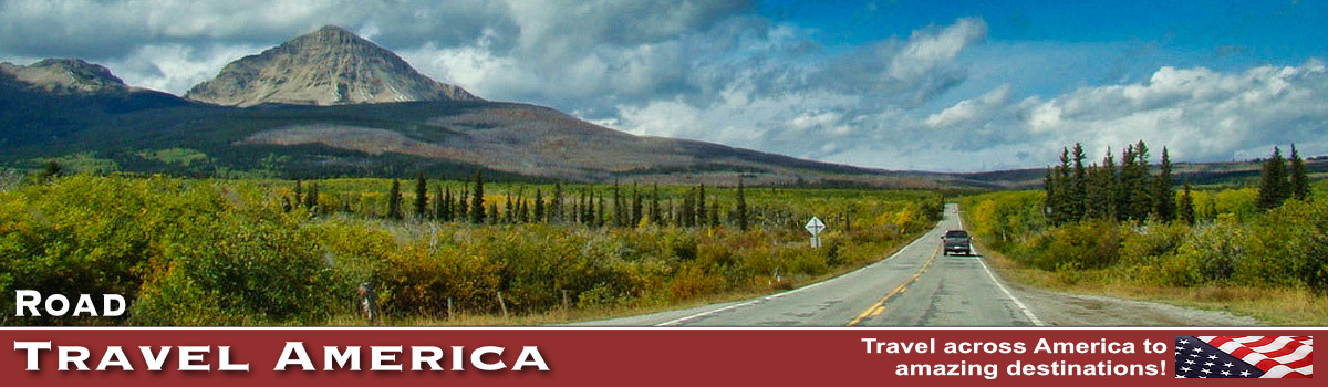
Travel on the Scenic Roads & Byways of America
We've traveled thousands of miles over hundreds of roads in virtually every state in the United States and several provinces in Canada.
Our journeys have taken us from Key West to Maine, from New York to California, from Arizona to Oregon, and Texas to Banff and Lake Louise. And many byways and back roads in between!
It's hard to pick the best, the most scenic, the one with the least traffic, or the most historic ... but here is a list of our favorites ... they might be the perfect road trip for you in 2026!
Listed below are some of the more popular road trips we have taken, and that our viewers have said they enjoyed.
Historic U.S. Route 66Route 66 was one of the United State's first continuous stretches of paved highway, and served as a major path for those who migrated west. "The Mother Road" was established on November 11, 1926, and ultimately stretched 2,448 miles from Chicago to Los Angeles. From its beginning in Chicago, Route 66 headed south through Illinois and Missouri, and a small section of Kansas. From there it turned in a more westward direction through Oklahoma and Texas, with the final stretches in New Mexico and Arizona before its termination point in Los Angeles. Route 66 became one of the most famous roads in the United States, outdistancing others such as the Lincoln Highway. It is popular lore in movies, songs, books, and TV shows. And the road was known far and wide for its variety of "mom and pop" motels, neon lights, drive-ins, flat tires, cars with no air conditioning, dangerous curves, steep hills, narrow lanes. The popularity stuck, and grew! |
|
Million Dollar HighwayThe 25-mile section of U.S. 550 from Silverton to Ouray in Colorado is frequently called the Million Dollar Highway. Though the entire 25-mile stretch is known as the Million Dollar Highway, it is really the 12 miles (19 km) south of Ouray through the Uncompahgre Gorge to the summit of Red Mountain Pass which gains the highway its name. This stretch through the gorge is challenging and potentially hazardous to drive; it is characterized by steep cliffs, narrow lanes, and a lack of guardrails. Along the way, drivers enjoy sites of the Uncompahgre Gorge, Idarado Mine, Animas River, San Juan National Forest, Haviland Lake, Elektra Lake, Twilight Peak, Red Mountain Pass, and more "million-dollar" views of the American West.
|
|
Loneliest Road in America: U.S. 50 Across NevadaU.S. Highway 50 (US 50) is a historic transcontinental highway which stretches from Sacramento, California in the west, to Ocean City, Maryland on the east coast. The highway crosses the central portion of Nevada, from the west side of the state near Lake Tahoe to the east side near Great Basin National Park. The route was constructed over a historic corridor, first used for the Pony Express and Central Overland Route, and later for the Lincoln Highway. The Nevada portion of U.S. 50 was named "The Loneliest Road in America" by Life magazine in July 1986.
|
|
Beartooth Highway in Montana and WyomingThe Beartooth Highway, U.S. Highway 212, is considered one of the most scenic drives in the United States. It includes views of the Absaroka and Beartooth Mountains, and open high alpine plateaus. The road features glacial lakes, forests, valleys, waterfalls and a variety of wildlife. The highway is the highest elevation highway in Wyoming and Montana, and is the highest elevation highway in the Northern Rockies. It traverses a series of steep zigzags and switchbacks along the Montana-Wyoming border to the 10,947 ft high Beartooth Pass. The Beartooth closes each winter because of heavy snow and adverse winter conditions; it usually reopens in May of each year.
|
|
Blue Ridge Parkway in Virginia and North CarolinaThe Blue Ridge Parkway offers a slow-paced and relaxing drive revealing stunning long-range vistas and close-up views of the rugged mountains and pastoral landscapes of the Appalachian Highlands. The Parkway meanders for 469 miles through Virginia and North Carolina. The north end of the Parkway begins near Waynesboro, at the southern end of the Skyline Drive. Millions of visitors annually enjoy the natural beauty and diversity of the Parkway. Spanning the southern and central Appalachians, the Blue Ridge Parkway offers an exceptional glimpse of the regional flora and fauna.
|
|
Going to the Sun RoadThis winding road traverses Glacier National Park in Montana from east to west, from St. Mary to Agpar, a distance of about 50 miles. Portions of Going to the Sun Road remain open all year and provide access to many locations and activities. The opening of the alpine portion varies, based on snowfall and plowing progress. There is no set date for the road to open; many years it is only open from late June to late September.
|
|
Utah Scenic Byway 12Scenic Byway 12 spans a route of 123 miles in southern Utah, and travels through some of the most diverse, remote and ruggedly beautiful landscapes in the country. It has been designed an "All-American Road". Highway 12 passes through Red Canyon, Bryce Canyon National Park, Grand Staircase-Escalante National Monument and over Boulder Mountain in the Dixie National Forest to its termination in Torrey near the entrance to Capitol Reef National Park. It is a popular connecting road for tourists visiting both Bryce Canyon and Capitol Reef national parks.
|
|
Trail Ridge Road in ColoradoTrail Ridge Road is a paved, 48 mile long scenic highway which connects the entrances of Rocky Mountain National Park in Grand Lake and Estes Park. It features switchbacks and hairpin curves, and rises to a height of 12,183 feet above sea level. The road is open seasonally in non-winter months. Leaving from either side of the park, the road climbs 4,000 feet in a matter of minutes. Numerous pull-outs and vistas are provided for visitors. The road is the highest continuously paved highway in the United States.
|
|
Burr Trail from Boulder to Bullfrog, UtahThe Burr Trail, which ends (or begins) at Boulder, Utah, is one of our favorite back roads in the country. It is typically quiet, with little or no traffic. In earlier years the entire length of the road was dirt; today parts are paved. The drive and views are stunning! The switchbacks are breathtaking! The road which connects Boulder with Bullfrog, and passes through the painted rock country of Glen Canyon National Recreation Area, Capitol Reef National Park, and Grand Staircase-Escalante National Monument land is known as the Burr Trail. The Burr Trail takes the adventurous traveler into some of Utah's most beautiful and extraordinary country, with views of the Henry Mountains, the colorfully contorted Waterpocket Fold, red Circle Cliffs, and Long Canyon.
|
|
The Moki Dugway in UtahThe Moki Dugway is a steep, gravel three mile road located in southeastern Utah, traversing 1,200 feet from the top of Cedar Mesa to the broad valley below. The road is actually part of Utah Highway 261, most of which is paved. Utah 261 is part of the Trail of Ancients, a National Scenic Byway that stretches across 480 miles through Colorado and Utah. The highway connects Utah Highway 95 with US Highway 163 by crossing Cedar Mesa and plunging down the dugway at an 10% grade, revealing sweeping views of Valley of the Gods, stripes of color in the rocks of the San Juan River Canyon known as the Navajo Tapestry, and distant Monument Valley. Allow 1 hour travel time for the entire length of Utah Highway 261. The gravel section of 261, the Moki Dugway, is well maintained and open all year, but road closures can occur, so be sure to check conditions before traveling to this area. During and after a rain or snow storm, the road may be impassable, even with a four-wheel-drive vehicle and can easily get muddy if it rains making it challenging to get through.
|
|
Monument Valley Scenic RoadThis is a 17-mile dirt road, at Monument Valley, in the Four Corners area on the Utah-Arizona border. Visitors may explore the scenic drive through the park in private vehicles or book a half-day or full-day jeep tour to explore the area's backroads and sacred lands with the help of a local guide. The road passes many notable features, including the Mitten Buttes, Three Sisters, Yei-bi-chai, North Window, and the famous Totem Pole. Passenger cars can drive the road, although care must be taken in loose sand and rocky areas. Nearby is famous Utah Route 163, seen in the film with Forrest Gump!
|
|
Tioga RoadLocated in central California, Yosemite National Park was established in 1890 and attracts five million annual visitors. State Route 120, the Tioga Road, crosses Yosemite National Park east to west, a distance of about 66 miles. This road is open when weather allows, as the Tioga Pass at 9,943 feet makes it the highest elevation served by CalTrans. The road usually opens by Memorial Day and often stays open as late as Thanksgiving.
|


Road Trip Ideas and Destinations by State
Do you need more road trip ideas? We have personally driven many of the following roads!
| State / Province | Scenic Highway or Byway |
| Alaska | Seward Highway - runs 125 miles from Seward to Anchorage through the scenic Kenai Peninsula, Chugach National Forest, Turnagain Arm, and Kenai Mountains. It is numbered Alaska Route 9 (AK-9) for the first 37 miles from Seward to the Sterling Highway and AK-1 for the remaining distance to Anchorage. |
| Alaska | James Dalton Highway |
| Alberta | Icefields Parkway |
| Arizona | Apache Trail Scenic Drive - links Apache Junction at the edge of the Greater Phoenix area with Theodore Roosevelt Lake, through the Superstition Mountains and the Tonto National Forest. It inclues 40 miles of steep, winding and mostly unpaved road past mountains and lakes, and through beautiful forest land. |
| Arizona | Gates Pass Road - between Tucson and Saguaro National Park |
| Arizona | Globe to Show Low - traverse 83 miles on US Highway 60 and Arizona Highway 77, from the dry Arizona desert, up the Mogollon Rim to the Colorado Plateau, through Salt River Canyon, and the Ponderosa pine forests of the White Mountains. |
| Arizona | Highway 89A from Sedona to Flagstaff - Just south of Flagstaff, Arizona State Route 89A descends a breathtaking series of switchbacks into a scenic, smaller cousin of the Grand Canyon. Known for colorful rocks and unique formations, Oak Creek Canyon is famous the world around for its spectacular scenery. Once you've snaked your way down the switchbacks, SR 89A winds a lazy course down the length of Oak Creek Canyon. |
| Arizona | Kayenta to Monument Valley Scenic Road |
| Arkansas | Arkansas Highway 7 - extends from the Louisiana border north 297 miles to Bull Shoals Lake near Missouri |
| Arkansas & Oklahoma | Talimena Scenic Byway - winds 54 miles along the crest of Rich Mountain and Winding Stair Mountain in the Ouachita National Forest. Runs from Talihini, Oklahoma, eastward to Mena, Arkansas. Spectacular in the fall. |
| British Columbia | Revelstoke to Golden - an incredible road trip that some would call dangerous, with few guardrails and narrow lanes |
| California to Illinois | Route 66: The Mother Road |
| California | Rim of the World Scenic Byway - This 110-mile route traverses the rim of the San Bernardino Mountains from Cajon Pass to San Gorgonio Pass. It travels through some of the most naturally beautiful areas in Southern California. Spectacular vistas and panoramas exist everywhere along the route. This Byway encompasses portions of California Highways 138, 18, and 38. This Byway is open year-round, but you may need chains in the winter as this area does receive snow. |
| California | 17-Mile Drive - a scenic road through Pebble Beach and Pacific Grove on the Monterey Peninsula, much of which hugs the Pacific coastline and passes famous golf courses, mansions and scenic attractions |
| California | Tioga Road - 39-miles of California State Route 120, running from Crane Flat through Tuolumne Meadows to Tioga Pass. Open only part of the year. Be sure to visit nearby Yosemite National Park. |
| Colorado | Mount Evans Scenic Byway - Highest paved road in North America through alpine lakes and ancient bristlecone pine. |
| Colorado | Pikes Peak Highway - Built in 1915, this winding road is the perfect scenic drive, offering views of lakes, mountains, wildlife and the surrounding area. Today, it is a 19-mile paved road full of majestic views, scenic pull-offs, and driving challenges, located in Cascade, Colorado, just west of Colorado Springs. To get there from Colorado Springs, go west on Highway US-24 and turn left onto Fountain Ave. The round-trip journey takes about 2-3 hours, not including stops for photos, time spent at the summit and other activities. There are no gas stations along the highway. The highway's entrance begins at 7,400 feet and climbs all the way up to 14,115 feet to the summit of the mountain. |
| Colorado | San Juan Skyway - Million Dollar Highway (U.S. 550) - near Silverton and Ouray. Miles of curves with no guardrails and short shoulders, but plenty of switchbacks and hairpin curves. The 12 miles from south of Ouray through the Uncompahgre Gorge to the summmit of Red Mountain pass are among the most challenging. |
| Colorado | Trail Ridge Road in Rocky Mountain National Park |
| Florida | Tamiami Trail in the Everglades - Tamiami Trail is a 264-mile roadway (U.S. Highway 41/State Road 90) that was completed in 1928, to connect the growing cities of Tampa and Miami. Visit Everglades National Park |
| Idaho & Oregon | Hells Canyon Road - Starts across the River from the Cooperfield Campground in Oxbow, Oregon, and continues to Hells Canyon Dam |
| Idaho | Salmon River Scenic Byway - Following the same path Lewis and Clark traveled over two centuries ago, Salmon River Scenic Byway follows the Salmon River through the Salmon-Challis National Forest, serving as a natural pathway into Idaho’s rugged backcountry. |
| Michigan | M-22 in Michigan - This scenic 116-mile road runs along the Leelanau Peninsula portion of Lake Michigan with some amazing destinations along the way: wineries, vintage small towns, and the Sleeping Bear Dunes National Lakeshore. |
| Montana | Going to the Sun Road running east-west through Glacier National Park |
| Montana & Wyoming | Beartooth Highway - Completed in 1936, U.S. Highway 212 is considered one of the most scenic drives in the United States. It includes views of the Absaroka and Beartooth Mountains, and open high alpine plateaus. |
| Nevada | Red Rock Canyon Loop Drive |
| Nevada | U.S. Highway 50: Loneliest Road in America |
| North Carolina & Virginia | Blue Ridge Parkway |
| New Mexico | Turquoise Trail |
| New York | Seven Lakes Drive - Located in the Hudson Valley on the way to Bear State Mountain Park |
| North to South in the U.S. | Road to Nowhere - U.S. 83 |
| Ohio | Covered Bridge Scenic Highway |
| Oregon | Columbia River Gorge Drive |
| Oregon | Mt. Hood Scenic Highway |
| South Dakota | Iron Mountain Road 16A, 17-miles of curves, pigtail bridges and switchbacks in the Black Hills near Mount Rushmore Memorial Park |
| Tennessee | Tail of the Dragon (U.S. Route 129) - 318 curves in 11 miles |
| Utah | Burr Trail Scenic Backway |
| Utah | Colorado River Scenic Byway |
| Utah | Cottonwood Canyon Road |
| Utah | Moki Dugway |
| Utah | Monument Valley 17-Mile Road |
| Utah | Shafer Canyon Road - 18 miles of dirt and switchbacks near Moab. Requires careful transit via vehicles and bikes. |
| Utah | Utah Scenic Byway 12, including the famous Hogsback |
| Virginia | George Washington Memorial Parkway |
| Virginia | Skyline Drive |
| Road tripping through Denali National Park in Alaska (NPS) |
 |
Trending Destinations |
|||
 |
 |
 |
 |
 |
 |
 |
 |
 |
 |
 |
|